 |
Adventures in Camping, Backpacking, Trail Running, and Canyoneering Moab's Red Hot 50K 2009 |
> Home
|
Running/Hiking Time | Race/Trail Description
Having completed a different 50K in the area a couple of months before---Ultimate XC Moab 50K--- (www.ultimatexc.com), I wanted to return back to an area of Utah I really enjoy and try a different race, one that I planned on doing last year, but was unable to attend. As I have mentioned in other reports, I tend to be a very back-of-the-pack runner. I start running at the back at the starting line and pretty much remain at the back the entire race, which suits me just fine. The main reason why I do these races is to challenge myself within my abilities and enjoy the scenery along the way.
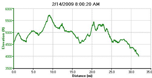
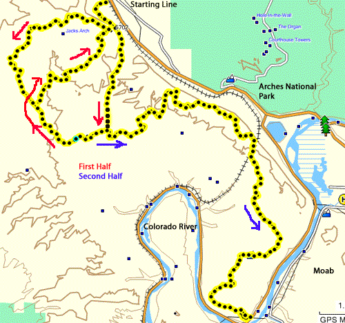
Moab's Red Hot is called a 50K race (about 31 miles), but the race promoters clearly indicated that it is actually about 56K (34 miles). There are two climbs, a gradual one of about 1,100 feet from mile 3-10. The second one is more of a grind of almost 1,000 feet from mile 18 to 23. Much of the first 18 miles is sandy jeep trails with some spots of slick rock; the last part of the race is one undulating slick rock--hard on the knees and body. As compared with the Ultimate XC 50K, I would say that this race was less technically challenging---fewer climbs, less sand, and few hands on manuevers---but still a hard and fun race for me.
A hiker could either do the first 20 miles in a loop back to the start at Gemini Bridges---if you park your car there---a very long haul and not as scenic as the last half of the race. I would much prefer to hike the second part of the course---a one-way route requiring two vehicles if you traveling from Gemini Bridges, up the Gold Bar Rim Trail and then southwest down the Poison Spider Trail. This second leg is about 20 miles from Gemini Bridges to the end.
Date: February 14, 2009
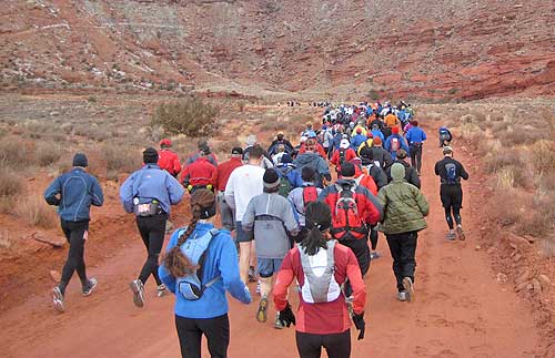
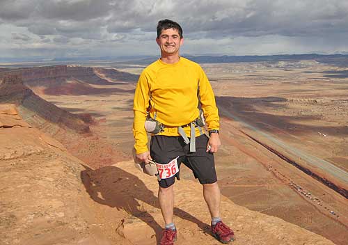
My brother, niece, and I traveled together down to Moab the night before and stayed at nice, little motel called Apache Inn. I was looking forward to a nice breakfast at the motel in the morning, but their breakfast service wouldn't start until 7:00 a.m., too late of a time for me to feel comfortable at getting to the starting line early enough to leave my drop back no later than 7:15 a.m. The skies were overcast, with a slight wind, and chilly temperatures, which ranged throughout the day in the 30s and low 40s. After a brief countdown, the 50K race began at 8:00 a.m., and I took my usual position at the back of the pack. (The 33K would start 30 minutes later.)
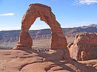
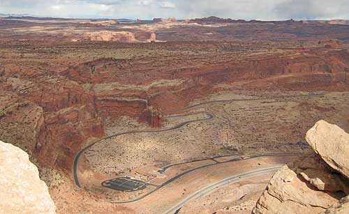
The 1.5 miles slowly climbed about 450 feet, thinning out the runners somewhat, then the jeep trail dropped and changed into a more sandy path until you reached a t-intersection at mile 3.75. The left fork would take you directly to the second part of the course, but we turned right up a sandy hill, winding up and around until the first aid station at mile 5.5. I refueled a little and was off. The course continued to climb slightly over the next few miles, crossing patches of slick rock that slowed the pace a little until you reach mile 10 with a beautiful view overlooking the starting line and parking lot 1,100 feet below. This was probably the most scenic point of the entire first half of the race. From this point, you continue northwest about a mile, now losing elevation, until the second aid station at about mile 11. Aid stations were stocked with water, chips, mini candy bars, and bananas. Unfortunately, the supplies---particularly water--- ran somewhat short for back-of-the-pack runners later in the race. Although I had kept a pretty constant pace until about mile 13, I decided to walk a short distance, and I then regained my pace before completing the loop back to the first aid station at about mile 17. The day had warmed up a touch, but I decided to grab an extra shirt at the aid station from my drop back in case it cooled, and I'm glad I did. From time to time, the cool breezes made wearing an extra layer more comfortable. By this point, I was looking forward to some extra snacks at this station, and they water and other snacks; only a couple of sandwiches remained, so I grabbed one, some juice from my drop back, and was off. It was about 11:30 a.m. when I pulled out of the aid station. Only about 5.5 miles---mostly uphill---to the next aid station.
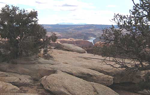
After about a 1.5 miles after the third aid station, runners are faced with the climb up the Gold Bar Rim Trail. (As it turned out, there was another make shift aid station right before the climb on the Gold Bar Rim Trail.) Not being a speed goat of any kind, it was a matter of hiking as quickly as I could for 3.4 miles to the top of the rim and the fourth aid station overlooking Arches National Park to the east at mile 22.4. A stopped for a minute or so and grabbed some peanuts and a couple of mini candy bars. I was hoping to pick up a small peanut butter and jelly sandwich that was said to be at the aid stations, but I was told by one of the volunteers that they were only given one loaf of bread for the aid station. Spread those few slices over a couple hundred runners who were ahead of me, and that equates to a few crumbs in the bottom of a bowl. No complaints though. Hey, I've you're not prepared for the unexpected on a trail run, you have no business participating.
From this point, the race route takes you up and down near the top of the rim for a couple of miles on uneven slick rock----no soft cedar chip and dirt trail. We ran into a couple of jeeps that had made their way well up the rough trail. I was hoping that I could pick up the pace a little, which I did, but the undulating hills of the slick rock and a number of sandy sections of the trail made things slower than anticipated. The weather remained good with temperatures around the 40s, with some cool breezes. Perfect weather for a run. I kept thinking that I would be able to pick up speed from the fourth to the fifth aid station (miles 22-29) along the Golden Spike Trail, but the undulating terrain, sand, and sore knees prevented me from cruising. At one part of the trail, runners had to pause to allow a Jeep and Hummer to downclimb a section of the trail. When I arrived at the final aid station (about mile 29), I was surprised to be asked by a volunteer if I really needed water. As it turns out, I was told later that the race officials hadn't anticipated the amount of water that the additional runners added for the event would consume. I was politely asked to only take what I needed because there were about 25 runners still behind me. Fortunately, the day was cool, and I still had a little water in one of my bottles, so I added a little water to my bottle and took off. Because I run at the back of the pack, I would probably leave a drop bag at this station with supplies so I wouldn't have to worry about water running out.
Once you get passed the last aid station, you know find yourself on a level stretch of Jeep trail and the beginning of Poison Spider Road. At first, I found myself bonking, so I walked for a distance until I was able to pick up speed a little. The trail then winds around as it descends towards the finish line. About two miles from the finish line, I runner coming the other way (perhaps someone who had finished earlier and was looking for a friend) announced that we were close to the end. Looking at my watch, I could see that if I picked up the pace a little, I'd make it under an earth-shattering 8 hours. (Actually, anytime I participate in such events, by the time I finish, the awards ceremony has already taken place, and the winners are probably now back at their hotels or enjoying an afternoon meal while my carcass is still out on the course.) As the course turned the final bend, I could see my wife, brother, and niece waiting down at the finish line only 100 meters or so away. What a nice sight after a long run. I crossed the finish line at 7:50 at the Poison Spider Trailhead, near the back of the pack, but breaking 8 hours was my main goal. There was hot soup waiting for us at the end of the race. The second part of the race is certainly more scenic than the first, so if you don't think you can complete the entire 50K, consider registering for the 33K option which covers the second half. Here are some things I learned from the race:
|
| Other Sites |