 |
Adventures in Camping, Backpacking, Trail Running, and Canyoneering Antelope Island 50K Trail Race |
> Home
|
Hiking Time | Trail Description | What to Bring
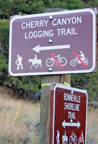
Orson Smith Trailhead (N 40.31.297, W 111.50.32) located near 12601 South 2000 East. You can routefind east up to the actual trailhead at N 40.31.250 W 111.49.767. The trailhead is marked as "Cherry Canyon Logging Trail", but it's also referred to Bear Canyon Trail. USGS Draper (UT). Click HERE to view the approximate starting coordinates and map.
So, how far are you planning to go? On this trip, our group traveled a little over five miles to the upper end of what I call Bear Canyon Bowl. It was a strenuous hike, particularly at the end where route finding was required up a dry creek bed.
About 10 hours round trip.
Date: September 1, 2006
The trail levels off somewhat before you reach a trail junction at N 40.30.824, W 111.47.908. At this point, you could head south and connect up with the Draper Ridge Trail (not the destination on this trip). Since we were heading to the Outlaw Cabin and beyond, we headed northeast and enjoyed the respite of the spade of aspen and spruce trees. At N 40.30.967, W 111.47.583, we found a spring (more like a seep) right off the right side of the trail, where you could fill your water bottles. The water should be fine to drink, but because it is right next to the trail used by horses, you might want to use a filter. On our return down the mountain, I whole-heartedly encouraged the group to drink away, but then one member noticed that I was the only one not drinking (I had plenty of water . . . so why the risk). From there, you encounter a steep section up through the trees, but then it levels off somewhat until you reach an beautiful open meadow to your left four hundred feet before Outlaw Cabin at N 40.31.200, W 111.46.883. If you walk north to the end of the meadow, you will be rewarded with a breathtaking view of the valley (Okay, that's what my companions told me--I arrived at the meadow at the same time they rejoined the trail on our way to the Cabin).
At any rate, continue up a short steep section of the trail, then veer right, and cross a small dry creek bed until you reach the Cabin. The cabin contains miscellaneous items (junk) inside, but it would be a place you could take refuge from a bad storm. Our group sat for a little while and rested before we continued our journey. From this point, we weren't sure if we should follow the trail behind the Cabin which would connect with the Jacob's Ladder Trail, of if we should head up the Bear Canyon drainage to reach Lone Peak, our original destination. We had read that following the drainage would be the shortest route to the summit, but we later realized that to be true in GPS miles but perhaps not in effort.
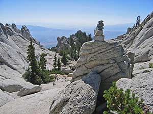
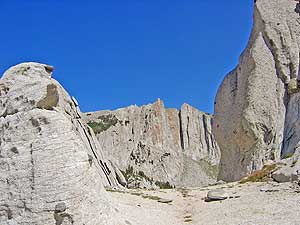
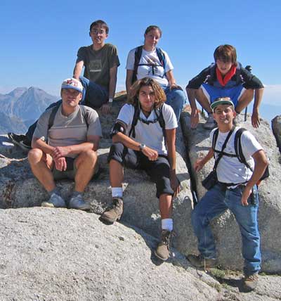
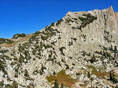
A midway point between the Cabin and the Bowl is at N 40.31.376, W 111.46.460. The climb isn't too difficult, but if your tired and thirsty, it can seem like the Sahara Desert. You'll know when you reach the impressive granite Bowl, which is a real change from what we had seen below. It's not huge by any means as compared with what you see east of you in the basin below, but it still ranks high up there. Our group took a picture on the edge of the Bowl at N 40.31.512, W 111.45.932, a point we called Forbidden Peak (Since we couldn't make it to Lone Peak, then we claimed a peak of our own.) We continued on at an easterly direction, following the carins, still thinking that beyond the Bowl, we could simply follow a level ridge line all the way to Lone Peak. WRONG! We finally reached a point that in order to ascend the traditional saddle to the top of the summit still .5 GPS mile away, we would first have to descend a good distance down to the cirque to the east and then make the arduous climb back up towards the summit. (Click HERE for a view where we stopped. The saddle in the distance to the left to climb is about at our same elevation, but we would have to descend and ascend it. Too tired for that.) I'm sure people might do this, but we realized that if we had taken the trail to Jacob's Ladder behind the Outlaw Cabin, we might have made a gentler approach to where we needed to ascend to the summit.
The return trip was easier in a way because we knew where we were heading. We used the same route back, stopping at the spring to fill up. The fun thing about a hike with others is that you can share thoughts about life, some of which apply to us all. Future plans, life successes, marriage, and a future date with the the beast, Lone Peak. This was definately a day to remember. Summary: The was a fun hike even though we didn't reach our original objective of reaching the summit of Lone Peak. The change of scenary through the forest and to Outlaw Cabin made it a pleasant hike. I might even try the hike again for just that reason. However, if your sole objective is to reach the summit, I might suggest taking a different route via Jacab's Ladder and then hit the cabin if you have enough energy and want to see different views of the mountain on the way down.
Commonsense, a lot of water, and food for the day. Having a GPS can be extremely helpful in pinpointing the route. Consider bringing a water filter if you are unsure about the water conditions at the spring.
|
 Once you reach the actual Cherry Canyon Logging Trailhead, your adventure begins. I went with a group of fun-seeking friends that included several international students from Iran, Japan, and Taiwan. The trail switches back as it climbs the first couple of miles, with several very nice viewpoints along the way. The plant life as well as the topography changes, from scrub oak at the bottom to twisty juniper trees farther up.
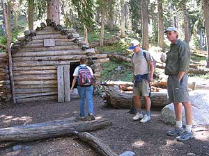
| Other Sites |