 |
Adventures in Camping, Backpacking, Trail Running, and Canyoneering Pika Cirque and Woolly Hole Basins |
> Home
|
Hiking Time | Trail Description | What to Bring
The Timpooneke Trailhead (N 40.25.885, W 111.38.365) is located about seven miles up American Fork Canyon following Highway 92. The trail begins on the south side of the parking lot. Be aware that the Great Western Trail (#151) crosses the Timpooneke trail right at the start, so be sure you are on the right trail. If you find the small ranger station and login area, then you know you are on the right path. Timpooneke Campground, USGS Timpanogos Cave (UT). Click HERE to view the approximate starting coordinates and map.
About 5 miles over some strenuous terrain for a loop that will return you back to your starting point. You might encounter a lot of loose rock, scree, some exposure, and bushwhacking along the way. Because the hike will take you to seldom-traveled areas, I definitely do NOT suggest doing this alone. If you are injured, no one will find you along the way.
About 6-9 hours one way depending on weather conditions and exploring.
Date: October 2006
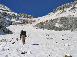
We started at the trailhead sometime after 8:00 a.m., leaving the car in the empty parking lot, and headed up the trail in the brisk winter-like weather. Recent snow draped many of the trees, and the peaceful surroundings (without the throngs of people of the trail on a normal summer day) make it a pleasurable ascent. We stopped here and there to look for geocaches placed on long the way until we reach the point where we needed to leave the trail at N 40.24.675, W 111.38.975 ascend to what I call Pika Pass.
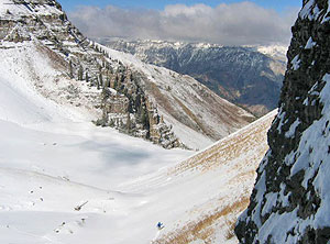
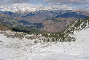
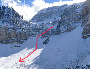
Things got warm due to the direct sun and our exertion, and I was considering removing another layer down to a t-shirt. However, with the end in sight near the top, I knew we would get a blast of cold air on the ridge, which proved to be true. Once at the ridge, we were amazed at the magnitude of the whole view into Pika Cirque, but we initially surmised that entering into the cirque might be more than we expected in the present weather conditions. However, searching briefly revealed a way to make a steep, but safe descent along the upper part the bowl. However, because we both were unsure what lay ahead in getting from Pika Cirque down into Woolly Hole, we made sure that we could retreat out of Pika in case we couldn't make a safe descent into Woolly. After a brief energy food break, Duncan headed down first as I followed behind.
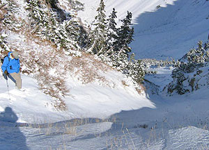
As we headed north, descending from the upper end, you quickly notice that you wouldn't want to be in the basin during an avalanche. Old tree trucks lay spewn all across the landscape, and it was hard to imagine what the area would look like in the summer. As we approached the lower end, there was a more wooded area to the east, which might make a nice place to camp, but we headed to the western rim to find an easier way to descend the basin. We did some route finding and decided to descend into the lower basin at N 40.25.594, W 111.39.589 and did some serious bushwhacking for a .5 of a mile down to the western tip of the Timpooneke. There are several gullies you might be able to use to descend from Woolly Hole, but be prepared to fight some brush along the way. Once down, we followed the road east back to the Timpooneke trailhead parking lot. Summary: This is a great hike well away from the crowds of the normal Timp hike, and it can be done in either direction. You can even turn this trip into a backpacking adventure, stopping over in either Woolly Hole or Pika Cirque for the night. Just keep in mind of the potential dangers of avalanches in the winter.
Commonsense, a lot of water, and food for the day. Having trecking poles can be of great use on some of the rough terrain.
|

| Other Sites |