 |
Adventures in Camping, Backpacking, Trail Running, and Canyoneering Antelope Island 50K Trail Race |
> Home
|
Hiking Time | Trail Description | What to Bring
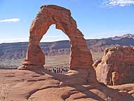
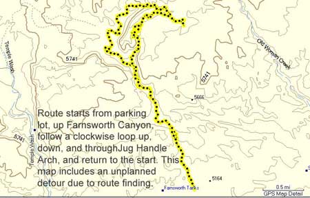
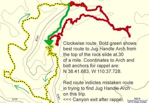
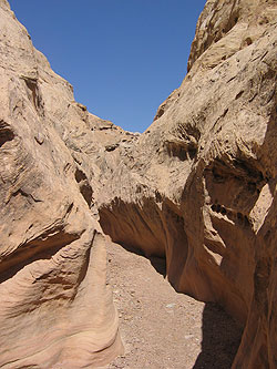
The entire adventure should be around 9 miles if you don't get lost routefinding as we did on our trip. To complete the route, you will need complete technical rappeling gear, and you can find out the more technical specifications from Tom's Utah Canyoneering Guide HERE. It is a moderate hike from the parking lot to the viewpoint overlooking the Jug Handle Arch. It may be possible to hike to this point and then route find from the top in an easterly direction back down to Farnsworth Canyon, but I've never taken that route.
About 6-9 hours round trip . . . unless you get stuck.
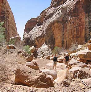
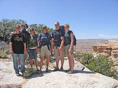
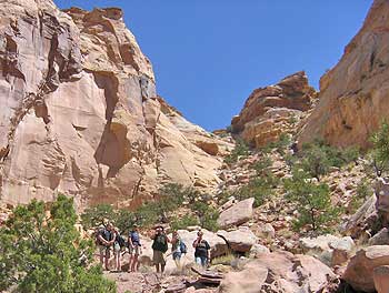
Date: April 19, 2008 While on a family campout in the area, I was invited to join on a "short" 2-6 hour hiking and rappelling adventure up Farnsworth Canyon. Tempted by the adventured (and encouraged by my wife to have a good time), I loaded my pack with the essentials and gear and headed out. After taking a little while to find the actual trailhead, we finally parked the truck, loaded up our packs, took a nice smiling picture, and headed out. Knowing how adventures can go awry or that multiple photo ops can take time, I was suspecting that we would be on the trail at the upper end of our predicted time of 6+ hours. Full of gusto, we marched out, making good time, and in a matter of a few minutes, we reached to mouth of Farnsworth Canyon at N 38.40.455, W 110.37.125.
After a futile search for a cold drink machine at this remote location, we consulted a map and mistakenly headed east based on our interpretation of some directions as to the location of three hidden arches. We knew the arches were about .3 miles from where we reached the top of the ridge. However, after wandering aimlessly about .7 miles east from where we summited the rock slide, we took another look at the map and a glance from where we came, we decided that we should have headed south-south east. One problem that complicated the matter was that there is an endless number of cairn all over the landscape, so while they probably lead you somewhere, they were, in this case, not leading us where we wanted to go.
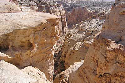
Refocused and back on the trail, we quickly retraced some of our steps and then recalculated where WE needed to go. Once we came to the rim of a series of deep canyons, we knew we had to be in the right area.
I first spied what is referred to as San Rafael bridge to the east, but as we spread out to look around, we located Hidden Bridge next, and then after a careful search, two others in our group, Brad and Kam, found the rappeling anchor bolts at N 38.41.683, W 110.37.728. What I first noticed, however, was a sling around a prominent rock formation nearby. At the time, I wasn't sure how this was part of the rappel through Jug Handle Arch, but after I returned from the trip, I ran across an article on rappeling down to the Hidden Bridge in the middle canyon right next door (click HERE for article). Since I've never done that possible route, I can't comment further one it, but from the placement of the sling, I now can see that might be possible.
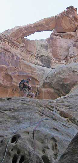
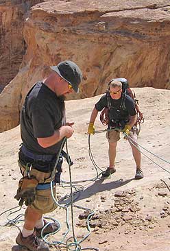
Once we had the ropes and gear set, Kam in our group decided to descend the first rappel down to scout things out. Basically, we were aware that we would have to rappel down about 30 feet through Jug Handle Arch, which was visible from the top, but the rest of the rappel down would be out of view after that. We were expecting that we would have to rappel down a total of 165 feet to some sort of ledge with bolted anchors for the next 50-rappel to the bottom of the first section of rappels, but we wanted to make sure everyone would fit (you don't want to be cramped on a precarious ledge). Fortunately, we had two-way radios which we used to communicate and pass on information about the ongoing rappel.
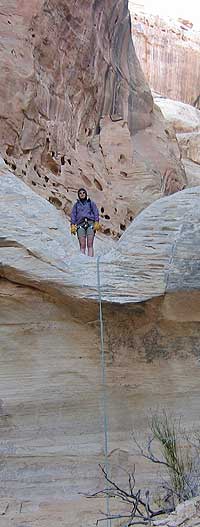
See Video - Windows Media Format (3 MB) After adjusting the ropes, Kam headed down about 30 feet to the arch, but he noticed that the rope he was on was frayed. Uhhhh. A frayed rope. A frayed rope and lots of weight on it don't usually make a good match. He said it was slightly frayed (and after examining it later, it would well have done the job for our group), and it was decided to switch ropes, so Kam found a "safe" spot to pause while the ropes were switched, and then he continued his descent out of sight. (Thanks, Kam, for your careful eyes.) After a few minutes, he radioed us that after some looking, found a bleached sling and bolts that were almost bleached white and seemed to blend into the surround rocks. However, he said that it would be possible to make the entire descent on a single 200-foot rope about to the bottom in one single rappel. Diane decided to make the descent next and went all the way to the sandy bottom. Yet, from a description we had brought of the rappels, there was supposed to be two more raps. I mean, when you hear there's a sandy bottom, you might assume that you're at the very bottom. Not so in this case. More later on this. By this time, we had spent almost two hours at the first rappel. After Diane, Kala, Lauri, and Jodie descended without a hitch, then I scared Brad, our final man, half out of his wits. As I was preparing to descend, I had too much slack in the rope, so as I went over the edge, I fell several feet and slammed against the canyon wall. Ouuuuuuuuuuuuuchhhh!! Now, that's not a keen way to boost your confidence when you've only gone five feet and you have 185 feet to go. Plus, I think I scared the pants off Brad. ("Man, why in the world did I bring Randy in the first place?"). Fortunately, the rest of my descent was uneventful, but truly a cool experience. Once I reached the bottom, Brad came down as the last man, and then the "fun" began.
Oh, no. Was it going to be a search and rescue mission to bail us out? Did anyone tell the other family members at camp exactly where we were going? Finally, after about 20 minutes or so of wrangling with the rope, it finally came down. Whew! With the temperatures dropping as the sun was setting, I was glad I wouldn't be spending the night there. Brad made the next, short 15-foot rappel first by passing the rope through a sling hooked around a rock, but I found it the most ackward rappel, climbing over some boulders then down straddling two walls and trying to avoid the splits. (Kala did a great job and kept her cool on the raps in spite of the heights.) From there, you can stay on rappel with the same rope and walk about 50 feet to the next 25-foot rappel. I wasn't sure what to expect from this one; it looked quite straightforward, but it had a tricky lip. After Jodie helped check my ropes (Thanks), I thought this one would be the easiest of them all, but instead of making a smooth, professional-looking descent, I almost flipped upside down . . . . but I was always in control. For those of you wondering, I wasn't in any danger of slipping out of my harness. From that point, there was a neat, short downclimb that lead us out of the canyon at N 38.41.399, W 110.37.769. However, if you wanted to hike back up the canyon instead of doing the rappel or wanting to meet people coming down, you can use these two other points to guide your way up:
N 38.41.613, W 110.37.684 (Head left at this fork)
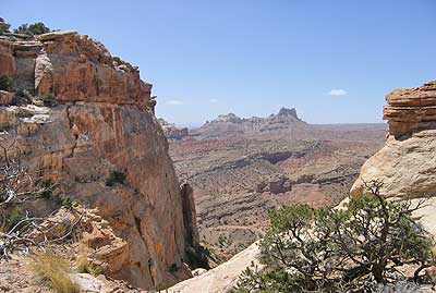
Back from where you left the canyon at N 38.41.399, W 110.37.769, you can continue in the wash until you reach N 38.41.322, W 110.37.738. At this point, the sun was almost down, and the moon was coming up, and we just retraced out steps back to the truck. We spent far more time doing the rappels than we thought we would, especially with the snafu with the rope on the first rappel. Total clocked time: 9:14. The family was somewhat worried about our returning that late, but others just commented that they just expected that. Summary: This was a real fun adventure with some great sandstone formations, a nice, short slot canyon, and exillerating rappels. The views from the top were incredible. We didn't see a single soul up top, which is great if you want some solitude particularly on a busy weekend.
If you're planning on doing the rappel, I'd consult Tom's Utah Canyoneering Guide HERE for more specifics. Particularly, you don't want to be caught without enough rope, and you should plan on bring full techical gear. Furthermore, I was glad we had radios to communicate with each other when we were out of sight on the rappels. There are no water sources along the way, so bring want you need. Having a GPS should help you find your way, particularly when it comes to locating the location of Jug Handle Arch and the bolts for securing your rope.
|
| Other Sites |